Beckford Gravel Pit
The Beckford site
Grid Ref: SO97783612
Importance: An important site of late Devensian slope and adjacent floodplain deposits, which are particularly significant in relation to environmental changed in the Severn basin. The exposure consists of sands and gravels, transitions between the two are sharp indicating a sudden transition between them.
The Devensian (120,000 – 10,000 years ago) contained the last glacial maximum in the UK. If these deposits are indeed Devensian they provide evidence of the Palaeoclimate at that time. The deposits suggest a cold, arid climate with significant wind-blown sand.
Visit report by Arline Gaskell
So many people wanted to attend the series of lectures given by Richard Edwards on The Evolution of Planet Earth that we couldn’t all fit in to St Matthias Church. He therefore gallantly but recklessly agreed to give each lecture twice every Wednesday for nine weeks. He and the Geology Group Committee then set up a field trip to give us the opportunity to see for ourselves evidence of some of the geological events and features that he had talked about. The number of would-be geologists inspired by the lectures and keen to go on the field trip meant that it had to be run on three separate days.
The first group set off on an unseasonably warm and sunny March day. Richard admitted that he had thought of several problems that might crop up but being blinded by the sun as he gazed at rock faces had not been one of them!
Our first stop was at Beckford, east of Tewkesbury. Half of us set off for the nearby geological site while the others enjoyed the delights of the coffee shop and we then swapped over.
Richard gave us a few minutes to examine the site with a view to coming up with three observations. Unlucky were those whose names he remembered as they were singled out to share their insights with the group!
From 1981-1987 sand was extracted from the Beckford gravel pit. When work finished, local residents managed to raise the money to buy the site and they now run it as a Nature Reserve. Near the entrance to the site is an exposed face with clearly defined but relatively narrow alternating layers of gravel and sand. The gravel layers consist mainly of bits of Cotswold limestone that are mostly angular, which indicates that they have not travelled far. These layers were probably formed when periodic flooding in bitter cold conditions caused the material to move downhill. The sand, on the other hand is not local so it is likely that those layers were blown in by winds.
The geological site report by the Herefordshire and Worcestershire Earth Heritage Trust points out that the gravel clasts are mostly about 10cm x 10cm x 1cm, with occasional larger pieces of limestone near the top of the cliff which indicate higher energy transport. This may have occurred as a result of deglaciation at the Devensian/Flandrian boundary, 10,000 years ago. In the lower gravel beds there is some disruption to the layers, suggesting possible slumping/buckling and frost heave. The sand grains are round and are mainly quartz but include some unidentified dark lithic fragments. The nearest source of such sand is in the Triassic sandstones of north-west Worcestershire. It is therefore likely that the area was subject to extremely low temperatures and very high winds, but was not covered by ice. The exposure may be Devensian (120-10ka) but this has not yet been confirmed.
The amount of work that Richard and the committee put into this whole venture is incalculable and we cannot thank them enough for such an enjoyable and memorable experience.
Pictures from the visit
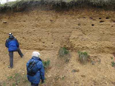
Members of the group at the base
of the exposure.
The sands and gravels would have been laid down in tundra conditions, when the
ground was frozen for the majority of the year. In the summer months there
would have been a thaw, with some movement of material down the slope under
gravity. This process in known as solifluction.
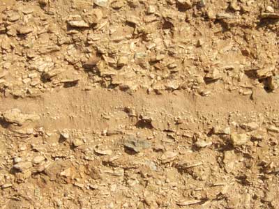
The exposure in close up. Note the alternating layers sands and gravels.
The gravel clasts are not
rounded, suggesting a movement of only a few hundreds of metres. They are mostly
oolitic limestone from Bredon
Hill.
Although the clasts layers are horizontal, the occasional individual one stands
on end. This re-orientation, or tepee action, is due to frost.
The sand is quartz. As well as
the layers between the gravels, there is also sand within the gravels clasts.
There is some debate as to where this sand originated from. Richard thought it
may have been wind borne from the clay in the glacier’s terminal moraines,
situated North of Herefordshire [examples next to the Roman Road near the
racecourse and at the churchyard in Burghill].
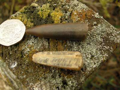
Belemnite fossils discovered in the exposure.